An essay for this gallery is available here. To return to the exhibition page, click here.
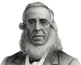
Founded by inventor, industrialist and philanthropist Peter Cooper in 1859, The Cooper Union for the Advancement of Science and Art offers education in art, architecture and engineering, as well as courses in the humanities and social sciences.
From its beginnings, Cooper Union was a unique institution, dedicated to founder Peter Cooper's proposition that education is the key not only to personal prosperity but to civic virtue and harmony.