GIS and Cartography for Designers: An Introduction
Cost: $535.00
2 in-person sessions
Saturday, June 24 & Sunday, June 25
10:00 am–5:00 pm
Location: 41 Cooper Sq.
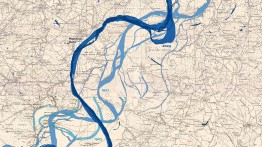
Get an introduction to the fundamentals of spatial thinking and Geographic Information Systems (GIS) while exploring the principles of cartographic design. This weekend workshop focuses on using open-source GIS tools (such as QGIS) to create custom maps that can be integrated into design projects using platforms like Adobe Creative Suite and Figma.
You’ll learn core GIS concepts, how to work with geospatial data, and how to translate maps into design-ready formats. Topics include navigating GIS software, transferring data into design platforms, and addressing challenges in cartographic styling, labeling, and hierarchy to create thoughtful, intentional map-based assets.
Through a series of hands-on exercises and brief presentations introducing the concepts of GIS and spatial thinking, students will make and design their own maps. Time will be built in for feedback and individual questions.
This course is designed for designers and creative professionals who want to incorporate geospatial data into their work. It’s a good fit if you’re curious about how data, logic, and design intersect—and are ready to build skills beyond traditional graphic design tools.
You don’t need to be a mathematician or coder to participate, but you should be:
- Comfortable working with spreadsheets and organizing data
- Open to engaging with math, spatial logic, and the concepts behind query languages (like SQL)
- Comfortable with technology and willing to try new tools
This course welcomes participants with or without prior experience in GIS, data, or code. If you’re ready to bring maps and data visualization into your design projects—and want to understand how data can drive design decisions—this workshop is for you.
Required Materials
- a laptop
- any analog sketching materials, if you find that helpful
Course Code: GIS1226
Instructor(s): Sara Eichner